Township Exteriors Manual of Instructions for the Survey of the Public Lands of the United States |
|
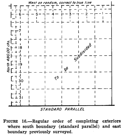
TOWNSHIP EXTERIORS Regular Order 3-17. The south and east boundaries of a township are normally the governing lines of the subdivisional surveys. Defective conditions in previously established exteriors cannot be eliminated where subdivisional lines have been initiated from or closed upon an old boundary, but the errors of former surveys are not incorporated into the new. Where the previously established south and east boundaries cannot on that account be used to govern the subdivision of the adjoining township, other controlling lines known as the sectional correction line and the sectional guide meridian are employed as expedient.
Meridional Boundaries 3-18. Whenever practicable the township exteriors are surveyed successively through a quadrangle in ranges of townships, beginning with the townships on the south. The meridional township boundaries have precedence in the order of survey and are run from south to north on true meridians. Quarter-section and section corners are established alternately, at intervals of 40 chains, and meander corners are established at intersections of the line with meanderable bodies of water. A temporary township corner is set at a distance of 480 chains, pending determination of its final position. The temporary point is then replaced by a permanent corner in proper latitudinal position. 3-19. A meridional exterior is terminated at the point of intersection with a standard parallel. The excess or deficiency in measurement is placed in the north half mile. A closing corner is established at the point of intersection. The parallel is retraced between the nearest standard corners to east and west to find the exact alinement, and the distance to the nearest corner is measured and recorded. 3-20. In order to complete the exteriors of a township it often remains to establish a meridional boundary between previously established township corners. Such boundaries are run from south to north on random lines, with temporary corners set at intervals of 40 chains. If defective conditions are not met with, the random is corrected to a true line. By this procedure, the excess or deficiency of measurement is placed in the north half mile, and double sets of corners are avoided where unnecessary. Latitudinal Boundaries 3-21. The latitudinal township boundary is run first as a random line, setting temporary corners, on a cardinal course from the old toward the new meridional boundary, and is corrected back on a true line if conditions are ideal. Where both meridional boundaries are new lines or where both have been established previously, the random latitudinal boundary is run from east to west. In either case, if defective conditions are not met with, the random is corrected back on a true line. Regular quarter-section corners and section corners are established at intervals of 40 chains, alternately, counting from the east, and meander corners are set where the true line intersects meanderable bodies of water. The fractional measurement is placed in the last half mile. 3-22. The bearing of the true line is calculated from the falling of the random. The falling is the distance, on the normal, by which a line falls to the right or left of an objective corner. The temporary points on any random line are replaced by permanent corners on the true line. The true line is blazed through timber, and distances to important items of topography are adjusted to correct true line measurement. Field Notes of Township Exteriors 3-23. The field notes contain a complete record of the manner in which township exteriors have been run and established. The direction of the projection of the random latitudinal curve, the amount of falling, and the calculated return course or true line are recorded in the field tablets but not in the final notes. The final field notes will contain a prefacing statement that random lines are omitted. The details of offsets, triangulations, and observations may be shown where a special purpose is served. Irregular Order and Partial Surveys 3-24. It is often necessary to depart from the ideal procedure. The possible combinations are too numerous to state in detail, but where an irregular order appears necessary, the departure from the ideal order is specifically outlined in the special instructions. The departure is always based on the principle of accomplishing the same relation of one township boundary to another as would result from regular establishment under ideal conditions. Some examples are illustrated in figures 22 through 27. 3-25. Where it is impracticable to establish the boundaries in full, it may be necessary to run section lines as offsets to township exteriors. Such lines are run either on cardinal courses or parallel to the governing township boundaries, and even may be established when subdividing, as existing conditions require. |
|
|
|
FIGURE 16. Regular order of completing exteriors where south boundary (standard parallel) and east boundary previously surveyed. |
Back to Surveying Info |